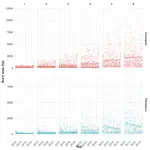
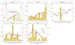
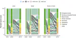
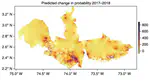
In the Amazon, climate and land use change are expected to intensify risks from weather disasters, posing major challenges to people and ecosystems. Yet, how weather disasters already affect the peoples of Amazonia remains understudied. To quantify regional impacts, we compiled and analyzed reports on weather disaster category, frequency, human, and economic impacts from 2013 to 2023 across five Amazonian countries. We counted 12,541 disaster reports, affecting up to >3 million Amazonians and >100,000 pieces of public infrastructure in a single year. There were disproportionate concentrations of landslides in the Amazon-Andes of Ecuador, and fires associated with agricultural management and sometimes land grabbing in the Orinoco-Amazon ecotone of Colombia and along the southern Arc of Deforestation of Bolivia and Brazil. We argue that weather disaster impacts in the Amazon are underreported because: 1) data from four Amazonian countries could not be obtained, 2) cross-country reporting was not standardized and 3) it varied such that virtually all heatwave and most drought data came from Brazil, despite published evidence that both disaster types are present throughout the region. Disaster impacts are already significant, underscoring the need for transboundary policies on land use, local adaptation strategies for communities and infrastructure, and coordinated regional efforts to share and update weather disaster management plans. Developing consistent, accessible, and interoperable datasets across the region is fundamental to building a comprehensive understanding of weather-related disasters in the Amazon and to informing effective public policies that strengthen prevention, response, and adaptation efforts.. These findings and recommendations provide a basis for discussing regional climate hazards at CoP30 in Belém do Pará, Brazil, in November.